The Quran on Clouds
- The Scientific Miracles in the Holy Quran
- The Quran on Human Embryonic development page 1
- The Quran on Mountains
- The Quran on the Origin of the Universe
- The Quran on the Cerebrum
- The Quran on Seas and Rivers
- The Quran on Deep Seas and Internal Waves
- The Quran on Clouds page1
- Scientists' Comments on the Scientific Miracles in the Holy Quran
- The Great Challenge to Produce One Chapter Like the Chapters of the Holy Quran
The Quran on Clouds:
Scientists have studied cloud types and have realized that rain clouds are formed and shaped according to definite systems and certain steps connected with certain types of wind and clouds.
One kind of rain cloud is the cumulonimbus cloud (thunderstorm). Meteorologists have studied how cumulonimbus clouds are formed and how they produce rain, hail, and lightning.
They have found that cumulonimbus clouds go through the following steps to produce rain:
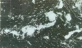
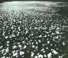
- The clouds are pushed by the wind: Cumulonimbus clouds begin to form when wind pushes some small pieces of clouds (cumulus clouds) to an area where these clouds converge (see figures 17 and 18).

Figure
17: Satellite photo showing the clouds moving towards the convergence areas
B, C, and D. The arrows indicate the directions of the wind. (The Use of
Satellite Pictures in Weather Analysis and Forecasting, Anderson and others,
p. 188.)

Figure
18: Small pieces of clouds (cumulus clouds) moving towards a convergence
zone near the horizon, where we can see a large cumulonimbus cloud. (Clouds
and Storms, Ludlam, plate 7.4.)
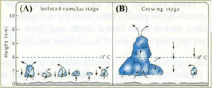
- Joining: Then the small clouds join together forming a larger cloud (see figures 18 and 19).

Figure
19: (A) Isolated small pieces of clouds (cumulus clouds). (B) When the small
clouds join together updrafts within the larger cloud increase, so the cloud is
stacked up. Water drops are indicated by
.(The Atmosphere, Anthes and others, p. 269.)
The source of this article is www.islam-guide.com
